Bengaluru Metro Map (Updated) – Namma Green & Purple Line Routes
The New Purple Line has been added to the metro .This is the updated Bangalore purple line Metro Map with complete list of all routes. The official Namma Metro has released the new Metro Map with all the metro station stops. You can go through the Bangalore Metro Map(updated) for Whitefield to Kengeri travellers. Earlier this year with launch of Purple line from Whitefield to KR puram people were eagerly waiting for the missing link from KR Puram to Bayapanhalli. That missing link has been filled. Metro from KR Puram to Bayapanhalli started its operation on Monday 9th October,2023. Now people dont have to take bus or cab to go from KR Puram metro station to Baypanhalli. This latest bangalore metro map will help you commute in the entire city without any trouble.
Check Namma Metro – Yellow Line Metro Route & Metro Stations here!!!
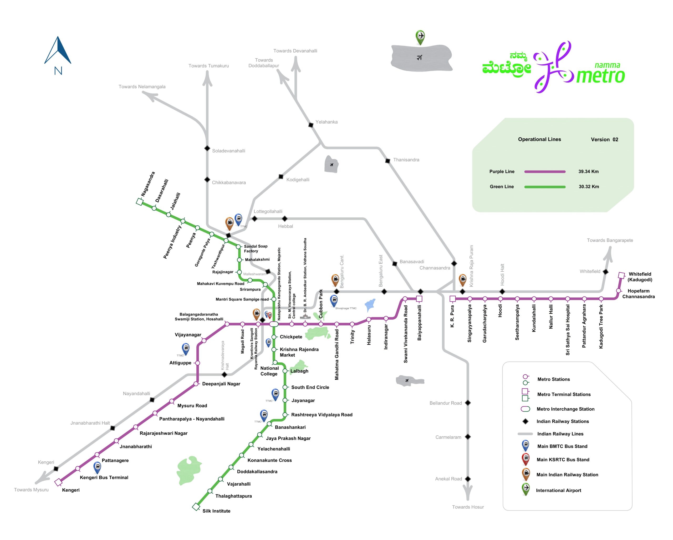
Map taken from Official Namma Metro Map Bangalore
Namma Metro Yellow Line – Metro Station list | Route
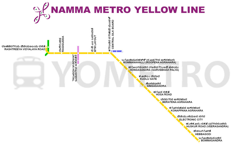
Image Source – yometro
The routes are mentioned in succeeding order. If you start from Kadugodi Whitefield then Kengeri is the last stop of Bangalore Metro Purple Line. If you start from Kengeri then Kadugodi Whitefield will be the last stop. The entire stretch from East to west can now be covered in just 80 minutes instead of hours and hours.
The Bangalore Metro purple line routes from Bangalore Metro Map (Updated)
- Kadugodi Whitefield
- Hopefarm Chanasandra
- Kadugodi Tree Park
- Patandur Agrahara
- Sri Sathya sai hopital
- NallurHalli
- Kundanhalli
- Seetharampalaya
- Hoodi
- Garudacharpalaya
- Singayanapalaya
- KR Puram
- Baiyapanhalli
- Swami Vivekananda Road
- Indiranagar
- Halasuru
- Trinity
- MG Road
- Cubbon Park
- Vidhana Soudha
- Sri M Visvesaraya Station,Central College
- Majestic Station
- Krantivira Sangolli Station
- Magadi Road
- Balagangadarantha Swamiji Station, Hosahalli
- Vijayanagar
- Attigupe
- Deepanjali Nagar
- Mysuru Road
- Pantharapalaya- Nayandahalli
- Rajarajeshwari Nagar
- Jnanabharathi
- Pattanagere
- Kengeri Bus Terminal
- Kengeri
The Bangalore Metro green line routes from Bangalore Metro Map (Updated)
- Nagasandra
- Dasarahalli
- Jalahalli
- Peenya Industry
- Peenya
- Goraghunte Palya
- Yeshwantpur
- Sandal Soap Factory
- Mahalakshmi
- Rajajinagar
- Mahakavi Kuvempu road
- Srirampura
- Mantri Square Sampige road
- Chickpete
- Krishna Rajendra market
- National College
- Lalbagh
- South End Circle
- Jayanagar
- Rashtreeya Vidyalaya road
- Banashankari
- Jaya Prakash Nagar
- Yelachenahalli
- Konankunte cross
- Doddakallasandra
- Vajrahalli
- Thalaghattapura
- Silk Institute
Details of Major Metro Stations along Purple Line Metro Route
Kadugodi Metro Station / Whitefield Metro Station
- Location: Kadugodi Metro Station is situated in the eastern part of Bangalore, specifically in the Kadugodi area, which is known for its residential neighborhoods and IT parks. It’s part of the Purple Line of the Bangalore Metro system. It is one of the ends of purple metro lines of Namma Metro in Bangalore as you can see in Bangalore metro map.
- Landmarks and Attractions: The station is conveniently located near several notable landmarks and attractions:
- IT Parks: Kadugodi is known for hosting several IT parks, including the International Tech Park Bangalore (ITPB), which is a major IT and business hub in the city. Many professionals working in the IT industry find this station particularly convenient for their daily commute. This area also has many pgs which is ideal for people working in ITPL, SJRI Tech Park and other prominent tech parks located in this area. There are many ongoing construction of Tech Parks which surely makes it one of the most hustling bustling metro station of Bangalore.
- Connectivity: Kadugodi Metro Station is well-connected to other parts of the city through the metro system and road networks. There is Kadugodi/ Whitefield Bus Stand also located opposite to metro line. It’s a key transportation hub for those traveling to the eastern suburbs.
- Station Facilities:
- Elevators and Escalators: The station is equipped with elevators and escalators for the convenience of passengers, ensuring accessibility for everyone, including those with disabilities. There is Nandini Milk Shop also which sells snacks and milkshakes. It is located at the ground floor outside metro station.
- Security: Security personnel and CCTV cameras are present to ensure the safety of passengers.
- Travel Tips:
- To avoid peak-hour crowds, it’s advisable to plan your commute during non-peak hours if your schedule allows.
- The station is a convenient entry point for those working in the nearby IT parks, and it’s a great option for commuters traveling to Whitefield and beyond.
- Cultural and Historical Insights: The area around Kadugodi has a mix of modern IT developments and historical sites. For instance, there are several old temples that add a touch of tradition to the area. There are many small food street areas in Kadugodi. These street food areas are lit up with people in the evening.
Hope Farm Metro Station (Chanasandra)
- Location: Hope Farm Metro Station is located in Chanasandra, a rapidly developing area situated in the eastern part of Bangalore. It is a key station on the Purple Line of the Bangalore Metro system. It is located at the junction of 4 crossing roads. As you can see in Banglore Metro Map Hope farm metro station comes just after Kadugodi/ Whitefield Metro station.
- Landmarks and Attractions: The station is in proximity to several landmarks and attractions:
- Hope Farm Circle: The station gets its name from the nearby Hope Farm Circle, which is a significant traffic junction. It serves as a reference point for those traveling to various parts of Whitefield and beyond.
- Educational Institutions: There are educational institutions in the vicinity, making it accessible for students and faculty. MVJ Engineering College is located to nearby Hope Farm Junction
- Connectivity: Hope Farm Metro Station plays a crucial role in providing easy connectivity to other parts of Bangalore, particularly the eastern suburbs. It eases the daily commute for residents and professionals working in this area.
- Station Facilities:
- Elevators and Escalators: The station is equipped with elevators and escalators to ensure the convenience of passengers.
- Security Measures: Security personnel and surveillance cameras are in place to enhance passenger safety.
- Local Services and Amenities:
- There are some shopping complexes located in the vicinity of Hopefarm Metro station.
- At the Hopefarm Signal there are many food outlets located. Eg A2B , Kathi Roll junction, Ice Cream shops etc
- Travel Tips:
- The station is especially beneficial for those working in the nearby IT parks and tech hubs in Whitefield, making it an important stop for daily commuters.It is an important junction for people travelling to ITPL, SJRI Tech park and other nearby areas.
- Consider checking the metro schedule for the Purple Line to plan your journey efficiently.
Sri Sathya Sai Hospital Metro Station, Whitefield, Bangalore
- Location: Sri Sathya Sai Hospital is located in the Whitefield area of Bangalore, Karnataka. It is situated on the Whitefield main road and is easily accessible from various parts of the city. It is located Opposite to SJRI Tech Park and Gopalan Global Axis Tech park.
- Overview: Sri Sathya Sai Hospital is a well-known healthcare institution that provides a wide range of medical services to the residents of Whitefield and the surrounding areas. It is a part of the larger Sri Sathya Sai Institute of Higher Medical Sciences. It provides treatment at a very less cost compared to private hospitals.
- Specialties: The hospital offers specialized medical services in fields such as cardiology, neurology, orthopedics, urology, ophthalmology, and more. It is equipped with modern facilities and a team of experienced medical professionals.
- It is one of the most important stations since Sri Satya Sai Hospital is located. There are lots of people who daily travel on this route.
KR Puram Metro Station, Bangalore
- Location: KR Puram Metro Station is located in the Krishnarajapuram (KR Puram) area of Bangalore, Karnataka. It is an important transportation hub in the city. It is also a center of whole sale products. If you see in Bangalore metro map KR Puram is at very crucial position for purple line metro as it is connecting point of east and west.
- Metro Line: The station is part of the Purple Line of Namma Metro, Bangalore’s metro rail network.
- Connectivity: KR Puram Metro Station provides excellent connectivity to various parts of Bangalore. It serves as a vital link between eastern and western parts of the city. There are lots of people who daily travel on this route because of there work.
- Bus Terminal: Adjacent to the metro station, there is a prominent bus terminal, making it convenient for passengers to switch between different modes of public transport.
- Commercial Area: The station area is surrounded by commercial and residential spaces, making it a busy and vibrant locality. Passengers can access various shops, eateries, and services in the vicinity.
- Transport Hub: Besides metro and bus services, KR Puram is also a significant railway junction in Bangalore, further enhancing its importance as a transportation hub. KR Puram junction has railway station, metro station as well as bus station. It makes it an excellent place for travelling to and from KR Puram.
- Commuter-Friendly: This metro station caters to the daily commuting needs of a diverse range of passengers, including office-goers, students, and residents of KR Puram and nearby areas.
- Connects East and West: Due to its strategic location, KR Puram Metro Station plays a crucial role in reducing travel time for those who need to traverse from the eastern parts of Bangalore to the western areas and vice versa.
- Future Development: As Bangalore’s metro network continues to expand, the importance of KR Puram Metro Station is likely to grow further, with increased connectivity and accessibility.
Baiyappanahalli Metro Station, Bangalore
- Location: Baiyappanahalli Metro Station is located in the Baiyappanahalli area of Bangalore, Karnataka. It is a crucial transportation hub in the city. Baiyappanahalli is next after KR Puram in Bangalore metro map. It is the starting point of West Bangalore.
- Metro Line: The station is part of the Purple Line of Namma Metro, Bangalore’s metro rail network.
- Interchange Station: Baiyappanahalli Metro Station serves as a significant interchange station, allowing passengers to switch between the Purple Line and the Green Line of the metro.
- Connectivity: This station provides excellent connectivity to various parts of Bangalore. It is particularly essential for those traveling between eastern and western areas of the city.
- Bus Terminal: Adjacent to the metro station, there is a prominent bus terminal, making it convenient for passengers to switch between different modes of public transport.
- Commercial Area: The station area is surrounded by commercial and residential spaces, ensuring passengers have access to various shops, eateries, and services in the vicinity.
- Convenient Transfer: Baiyappanahalli Metro Station plays a vital role in facilitating smooth transfers for passengers. Those arriving on the Green Line can conveniently switch to the Purple Line, and vice versa.
- Connects to KR Puram: For passengers who wish to continue their journey from Baiyappanahalli towards the eastern parts of Bangalore, the Purple Line connects to KR Puram Metro Station, which further extends the connectivity.
- Strategic Location: As a key metro station, Baiyappanahalli ensures that the Bangalore metro network serves a diverse range of passengers, from daily commuters to students and tourists.
MG Road Metro Station, Bangalore
- Location: MG Road Metro Station is located in the heart of Bangalore’s central business district. It is one of the most iconic and busiest metro stations in the city. MG road is a very important metro station of purple line metro.
- Metro Line: The station is a major interchange point on Namma Metro, Bangalore’s metro rail network. It connects both the Purple Line and the Green Line, making it a vital transportation hub.
- Interchange Station: MG Road Metro Station is unique in that it provides seamless connectivity between two metro lines, allowing passengers to switch between the Purple Line and the Green Line easily.
- Commercial Hub: The station’s strategic location makes it a bustling commercial center. It’s surrounded by numerous offices, shopping complexes, restaurants, and retail outlets, making it a favorite for both commuters and shoppers. MG Road has many pubs, restaurants, cafes and mall. This makes an ideal place from all over the bangalore to reach this place.
- Public Transport Hub: MG Road is a key junction for various modes of public transport, including BMTC buses and auto-rickshaws. It offers excellent connectivity to different parts of the city.
- Landmarks: The station is close to some of Bangalore’s iconic landmarks, including Brigade Road, Cubbon Park, and Vidhana Soudha. This makes it a preferred choice for those exploring the city.
- Heritage Line: MG Road Metro Station is a part of Namma Metro’s Purple Line. It connects areas like Baiyappanahalli and Mysore Road. Passengers can easily travel to different corners of the city using this line.
- Green Line Connectivity: This station also provides easy access to the Green Line of Namma Metro, which connects areas like Nagasandra and Yelachenahalli. It’s a significant convenience for commuters traveling across the city.
- Shopping Paradise: For those who love shopping, MG Road Metro Station’s vicinity is a paradise. Brigade Road, one of Bangalore’s famous shopping streets, is within walking distance.
Cubbon Park Metro Station, Bangalore
- Location: Cubbon Park Metro Station is situated in the heart of Bangalore, close to the historic Cubbon Park. It serves as a key entry point for visitors to the park and provides easy access to various attractions in the city.
- Metro Line: The station is part of Namma Metro’s Purple Line. This line connects areas like Baiyappanahalli and Mysore Road, offering a convenient mode of transportation for commuters.
- Cubbon Park Access: As the name suggests, Cubbon Park Metro Station provides direct access to Cubbon Park, one of Bangalore’s most famous parks. It’s an ideal starting point for those planning to explore the park’s lush greenery, walking trails, and historical monuments.
- Majestic Interchange: Cubbon Park Metro Station is a key station on the Purple Line and serves as an interchange station with the Green Line at Majestic, providing passengers with seamless connectivity to different parts of the city.
- Cultural and Heritage Hub: Apart from Cubbon Park, the station’s proximity to historical landmarks like the Karnataka High Court, Vidhana Soudha, and the Visvesvaraya Industrial and Technological Museum makes it a hub for cultural and heritage enthusiasts.
- Educational Institutions: Several educational institutions, including St. Joseph’s College, are located in the vicinity of Cubbon Park Metro Station. This provides students and faculty members with an easily accessible mode of transportation.
- Walking Trails: For health-conscious individuals and nature lovers, Cubbon Park offers a network of walking trails. The metro station is a starting point for those who wish to enjoy a leisurely walk in the park’s serene surroundings.
- Public Transport Hub: Cubbon Park Metro Station is a hub for other modes of public transportation. BMTC buses, auto-rickshaws, and taxis are readily available, ensuring excellent connectivity.
- Shopping and Dining: There are several shopping and dining options around the station, making it convenient for commuters and tourists alike. The bustling MG Road is just a short walk away.
- Traveler’s Tips: Visitors planning to explore Cubbon Park or nearby attractions can use Cubbon Park Metro Station as a starting point. It’s also advisable to check the metro’s operational hours and any specific guidelines before your visit.
Majestic Metro Station, Bangalore
- Location: Majestic Metro Station, officially known as Kempegowda Interchange Metro Station, is a major transportation hub in Bangalore. It’s situated in the heart of the city at Majestic, where various modes of transportation converge.
- Metro Line: Majestic Metro Station is a crucial interchange point that connects Namma Metro’s Green Line and Purple Line. The Green Line extends from Nagasandra to Yelachenahalli, while the Purple Line spans from Baiyappanahalli to Mysore Road. This makes Majestic a pivotal station for commuters.
- KSRTC Bus Stand: The station is adjacent to the Kempegowda Bus Station, also known as the Majestic Bus Stand, which is operated by the Karnataka State Road Transport Corporation (KSRTC). This is one of the busiest bus stations in the city, providing connectivity to various parts of Karnataka and neighboring states.
- City Railway Station: Bangalore City Railway Station, another major transportation hub, is within walking distance of Majestic Metro Station. This proximity allows passengers to seamlessly transfer between metro and train services.
- Kempegowda Tower: The station is named after Kempegowda, the founder of Bangalore. There is a prominent Kempegowda Tower nearby, which adds to the historical significance of the area.
- Commercial Hub: The Majestic area is a bustling commercial hub, hosting numerous shops, restaurants, and businesses. Commuters can find everything from clothing stores to street food stalls in the vicinity.
- Connectivity: With the convergence of metro, buses, and trains, Majestic Metro Station offers unparalleled connectivity. This makes it a popular choice for commuters traveling to different parts of Bangalore and beyond.
- Shopping: The nearby Chickpet area is renowned for its textile and clothing shops. Shoppers often use Majestic Metro Station as a starting point for their shopping adventures.
- Local Landmarks: The station is close to several landmarks, including the Majestic Post Office and Sangolli Rayanna Circle.
- Traveler’s Tips: If you’re looking to explore different areas of Bangalore or need to transfer between metro lines, Majestic Metro Station is the ideal starting point. Given its central location, it can be crowded during peak hours, so plan your travel accordingly.
Majestic Metro Station is more than just a metro stop; it’s a transportation nexus that connects various modes of travel and serves as a gateway to the diverse experiences Bangalore has to offer. Whether you’re a daily commuter, a traveler, or a shopper, this station is a vital part of your journey through the city.
Kengeri Metro Station, Bangalore
- Location: Kengeri Metro Station is a significant station situated in the southwestern part of Bangalore. It’s located in the Kengeri satellite town, which is known for its residential and industrial areas.
- Metro Line: Kengeri Metro Station is a part of the Purple Line of Namma Metro, Bangalore’s metro rail system. The Purple Line stretches from Baiyappanahalli in the east to Mysore Road in the west, connecting various parts of the city.
- Kengeri Satellite Town: The station serves the Kengeri satellite town, which has witnessed rapid development in recent years. It’s a suburban area with a mix of residential and commercial establishments.
- Kengeri Campus: One of the prominent features of Kengeri is the presence of several educational institutions, including the Bangalore University’s Jnana Bharathi Campus and Rajarajeshwari Medical College and Hospital. This makes Kengeri a hub for students and academic activities.
- Connectivity: Kengeri Metro Station enhances the connectivity of the Kengeri area with other parts of Bangalore. Commuters can use the metro to reach central areas of the city conveniently.
- Kengeri Lake: Kengeri is also known for its picturesque Kengeri Lake, which adds a touch of natural beauty to the locality. The lake is a peaceful spot for a leisurely stroll or some relaxation.
- Residential Hub: The station caters to the residential population of Kengeri and the nearby areas. People living in these suburbs find the metro to be an efficient mode of transportation to reach their workplaces and explore the city.
- Industrial Presence: Kengeri has an industrial area that houses various manufacturing and production units. Workers and employees in this industrial hub can benefit from the metro station’s proximity.
- Ganesha Temple: There is a prominent Ganesha temple nearby, which is a religious and cultural center for the local community.
- Accessibility: Kengeri Metro Station offers accessibility for differently-abled individuals with facilities like ramps and elevators, in line with Namma Metro’s commitment to inclusivity.
- Development Prospects: With the continuous expansion of Bangalore’s metro network, Kengeri Metro Station is set to play a crucial role in the city’s transportation infrastructure. It holds potential for further development and growth in the surrounding areas.
Kengeri Metro Station is not just a transportation point; it’s a part of the burgeoning growth of southwestern Bangalore. It caters to the needs of residents, students, and professionals while contributing to the city’s overall connectivity and development.
Namma Metro in Bengaluru has approx 63 stations. A lot of people daily take these metro to travel across the city. Daily around 480 K + travellers board these Bengaluru metros. Every year 177 Million + travellers board these metro to reach there destination safely on time. This shows the popularity of Namma Metro in Bengaluru.
Namma Metro Help Line Number – 1800-425-12345
Email – travelhelp@bmrc.co.in
Conclusion
You can go through the Bangalore Metro Map (Updated) for Purple Line Routes(Whitefield to Kengeri stations) and bookmark this page for future reference. This map contains all the metro stations of Bangalore. For any further information you can contact. If you are looking for whitefield metro map or purple line metro map then you can refer this article.
Namma Metro Help Line Number – 1800-425-12345
Email – travelhelp@bmrc.co.in
If you want to get this article then you can search the following Keywords to find this article
whitefield metro map, bangalore metro map latest,purple line metro map,bangalore metro new map,bangalore metro map whitefield,bengaluru metro map,namma metro purple line map,bangalore metro purple line map,namma metro map bangalore,bangalore metro purple line map,bengaluru metro map,purple line metro map,bangalore purple line metro map,whitefield metro map,metro map bangalore 2023,bangalore metro new map,latest bangalore metro map,namma metro map